FINANCIAL REPORTS
PPT visuals to present your key numbers
Present Your Topic Visually:
Reviews
Ihre Grafiken verleihen meinen Präsentationen eine nette Note, und ich habe sie kürzlich für eines meiner All-Hands-Meetings verwendet. Ihre Toolbox verleiht meinen Folien Professionalität, anstatt Standard-Clipart zu verwenden.
Ich brauchte einen neuen Blick auf einige meiner Folien. Ich habe versucht, einen Weg zu finden, einen Pinselschlag-Effekt zu erzielen, um zu unterstreichen, hervorzuheben, Farbe hinzuzufügen, und die handgeschriebenen Markierungen waren genau das Richtige. Sehr einfach zu bedienen, leicht in der Größe zu ändern, die Farbe zu ändern. Es war eine erschwingliche, perfekte Lösung und ich empfehle sie gerne weiter.
Die klare, saubere Optik der Grafiken und die Tatsache, dass ich die Farben leicht bearbeiten und an die Vorlage anpassen konnte, war mein Hauptgrund für den Kauf.
Usage example
Description
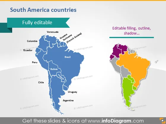
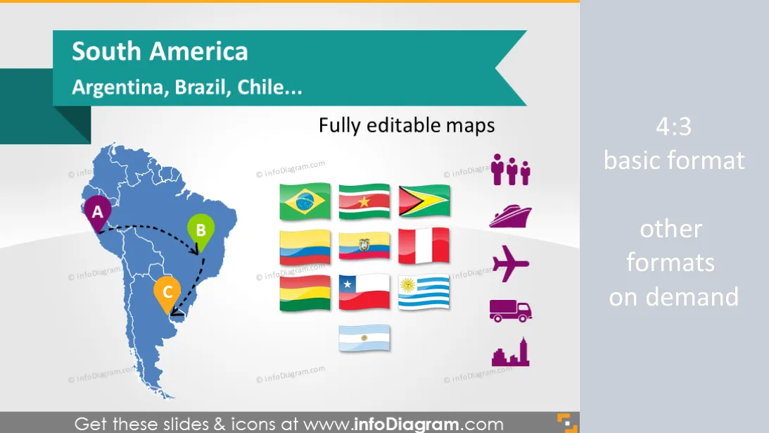
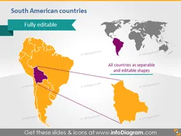
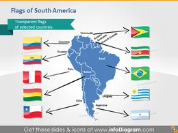
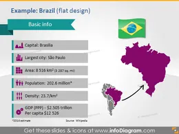
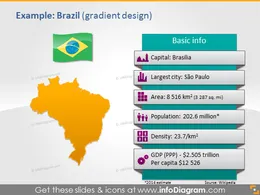
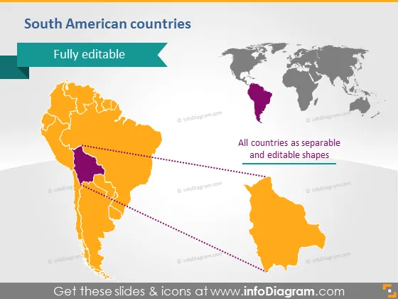
South America countries - editable PowerPoint maps, localization and transport icons, country statistics
- Maps of 13 countries and world: Argentina, Brazil, Chile...
- Flags of South America countries
- Localization icons: places, hand drawn arrows
- Data icons: population, density, GDP, capital, transport, production, distribution
- Fully editable maps, icons, arrows
Content
Set of vector maps editable in PowerPoint of South America countries
South America:
- Argentina
- Bolivia
- Brazil
- Chile
- Colombia
- Ecuador
- Guyana
- French Guiana
- Paraguay
- Peru
- Suriname
- Uruguay
- Venezuela
Examples of maps illustrations:
- Country statistics data: Population, Density, Area, GDP, Largest city, Capital
- World map with South America highlighted
Icons for showing localization and logistics on maps:
- Pins and flags for indicating a place
- Handdrawn arrows for showing routes and journeys
- Transportation icons: Truck, Train, Plane, Ship, Bus, Lorry for illustrating logistic routes on the South America map
- Production pictograms: Factory icon, Production facility icon, Production gears icon
- Distribution pictograms: Distribution centre icon, Wholesale icon, Consumption Retail shop icon
- City pictogram: Capital icon, Big city icon
Examples of PowerPoint maps visualization:
- Places pins and indicating time zone
- Routes from point A to point B and C in the South America (as handwritten arrows on a map)
- Transportation routes: flights and trains between the countries
- Production and distribution routes from factory to distribution centers and retail shops
- Distribution pictograms: Distribution centre icon, Wholesale icon, Consumption Retail shop icon
Further information sources on countries data
- South America region (Wikipedia )
- Countries list by GDP ( Wikipedia )
- GDP comparisons by World Bank, International Monetary Fund, CIA World Factbook ( Wikipedia )
- The World Factbook 2009. Washington, DC: Central Intelligence Agency ( CIA Factbook )
Acronyms used
- GDP – Gross Domestic Product
- PPP - Purchasing Power Parity
- sq mi – square mile
- km2 – square kilometer
Editable elements
Fully editable vector shapes by using built-in PowerPoint tools, including
- editing texts
- editing maps (color of the fill and outline, style - gradient, with outline, shadow, reflection)
- arrows and icon pictograms: changing fill color, size, style (gradient fill, outline, shadow, reflection)
- all elements are transparent (charts, maps, flags, arrows), you can put them behind or above your content
See editing demonstration in our HowTo Videos.
Author
- InfoDiagram contributor & Prezentio.com designers
- Contact: infoDiagram
Slides included in this PowerPoint Presentation:
- South America maps countries powerpoint Brazil Chile
- Southern America countries powerpoint editable Bolivia map
- PPT Flags Colombia Peru Chile Ecuador Guyana Venezuela Suriname
- Brasil PPT Map Flag Demographic data South America
- Brazil PowerPoint Map Flag Demographic Area Population data
- Argentina PPT Map Flag Demographic data South America
- Argentina PowerPoint Map Flag Area Population GDP data
- Colombia PPT Map Flag Statistics data South America
- Colombia PowerPoint Map Flag Capital Area Population Density GDP data
- World Map South America Continent countries PowerPoint
- World Map Editable Vector Clipart PowerPoint
- White World Map South America Continent countries PowerPoint
- PPT Maps Location Icons Pins Flags South America
- Population Area Time Icons Time Zone Powerpoint Clipart
- Transport Icons Truck Plane Train Ship Power Point
- Icons Production Factory City PowerPoint clipart
- Distribution Retail Shopping Warehouse Symbols PPTX Clipart
- Hand drawn Arrows Path Maps PowerPoint shapes
- PowerPoint Slide Time zone Icon Colombia Map South America
- South America Map Route Arrows Brazil Peru Argentina PPTX
- South America Map PPTX symbol Flight Routes Train Water Transport
- Production South America Distribution Symbol PPT clip art
How to Edit
How to edit text & colors

How to expand / shorten diagram

How to Replace Icons in infoDiagram PPT
