Your graphics add a nice touch to my presentations and I recently used them for one of my all-hands meetings. Your toolbox adds professionalism to my slides. Instead of using standard clipart.
Claude Jones, Director of Engineer, @Walmartlabs, USA
Your graphics add a nice touch to my presentations and I recently used them for one of my all-hands meetings. Your toolbox adds professionalism to my slides. Instead of using standard clipart.
Claude Jones, Director of Engineer, @Walmartlabs, USA
I needed a fresh look at some of my slides. I've tried to find a way to create a paintbrush effect, to underline, accentuate, add some color and the handwritten markers were just the things. Very easy to use, easy to size, change the color. It was an affordable, perfect solution and I'm happy to recommend it.
Anonymous, US
The crisp, clean look of the graphics, and the fact that it allowed me to easily edit and change the colors to match the template was my main reason for purchasing them.
Brandie Jenkins, E-learning Developer, USA
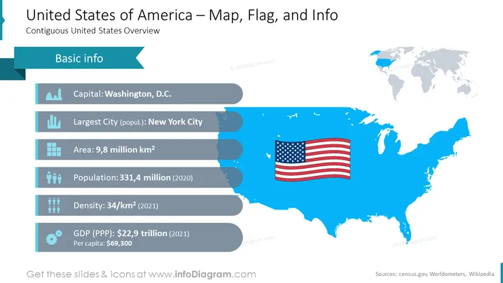
The slide provides an overview of the United States of America, titled "Contiguous United States Overview." It lists basic information such as the capital, which is Washington, D.C., emphasizing its political significance as the city where federal decisions are made. The largest city is New York City, signaling its economic and cultural impact. The area is indicated as 9.8 million km², showing the vast geographical span of the country. The population is noted as 331.4 million for the year 2020, reflecting the sizeable and diverse demographic. The density is measured at 34/km² as of 2021, which gives a basic idea of population distribution. Lastly, the Gross Domestic Product (GDP) in purchasing power parity (PPP) terms is $22.9 trillion, with a per capita income of $69,300 for the year 2021, showcasing the economic standing of the nation.
The slide is cleanly designed with a color scheme dominated by blue and white shades. The integration of icons with the corresponding text for each fact provides a clear and digestible format for the information.


