Your graphics add a nice touch to my presentations and I recently used them for one of my all-hands meetings. Your toolbox adds professionalism to my slides. Instead of using standard clipart.
Claude Jones, Director of Engineer, @Walmartlabs, USA
Your graphics add a nice touch to my presentations and I recently used them for one of my all-hands meetings. Your toolbox adds professionalism to my slides. Instead of using standard clipart.
Claude Jones, Director of Engineer, @Walmartlabs, USA
I needed a fresh look at some of my slides. I've tried to find a way to create a paintbrush effect, to underline, accentuate, add some color and the handwritten markers were just the things. Very easy to use, easy to size, change the color. It was an affordable, perfect solution and I'm happy to recommend it.
Anonymous, US
The crisp, clean look of the graphics, and the fact that it allowed me to easily edit and change the colors to match the template was my main reason for purchasing them.
Brandie Jenkins, E-learning Developer, USA
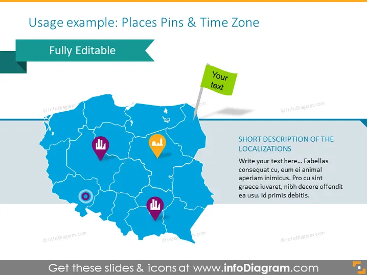
This PowerPoint slide presents a map-based visualization, labeled "Usage example: Places Pins & Time Zone", for annotating geographic locations with pins that could represent different data points or areas of interest. The pins on the map have distinct icons indicating various types of locations or information, such as points of commercial interest or landmarks. Accompanying these graphical elements are placeholders for text, enabling the user to add descriptions or important information about the locations marked by the pins.
The slide presents a visually appealing and professional design with its use of vibrant color contrasts and clean, modern graphics. These elements are well-arranged to facilitate clear communication of information through a combination of visualization and text.


