Your graphics add a nice touch to my presentations and I recently used them for one of my all-hands meetings. Your toolbox adds professionalism to my slides. Instead of using standard clipart.
Claude Jones, Director of Engineer, @Walmartlabs, USA
Your graphics add a nice touch to my presentations and I recently used them for one of my all-hands meetings. Your toolbox adds professionalism to my slides. Instead of using standard clipart.
Claude Jones, Director of Engineer, @Walmartlabs, USA
I needed a fresh look at some of my slides. I've tried to find a way to create a paintbrush effect, to underline, accentuate, add some color and the handwritten markers were just the things. Very easy to use, easy to size, change the color. It was an affordable, perfect solution and I'm happy to recommend it.
Anonymous, US
The crisp, clean look of the graphics, and the fact that it allowed me to easily edit and change the colors to match the template was my main reason for purchasing them.
Brandie Jenkins, E-learning Developer, USA
The earliest evidence of inhabitants in present-day Lithuania dates back to 10,000 BC. Between 3000 and 2000 BC, the people of the Corded Ware culture spread over a vast region of eastern Europe, between the Baltic Sea and the Vistula River in the West and the Moscow–Kursk line in the East. Merging with the indigenous peoples, they gave rise to the Balts, a distinct Indo-European ethnic group whose descendants are the present-day Lithuanian and Latvian nations and the former Old Prussians. Wikipedia
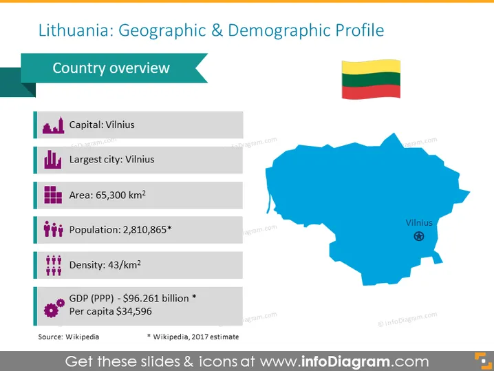
Want to share more recent demographic & geographic information about Lithuania? This presentation template illustrates the current map of the country and various demographic information inside a 6-row table.
This Lithuania Demographic & Geographic Map slide is a part of our Baltic States Europe Maps with Administrative Territories PowerPoint Template.


