

Your graphics add a nice touch to my presentations and I recently used them for one of my all-hands meetings. Your toolbox adds professionalism to my slides. Instead of using standard clipart.
Claude Jones, Director of Engineer, @Walmartlabs, USA

Your graphics add a nice touch to my presentations and I recently used them for one of my all-hands meetings. Your toolbox adds professionalism to my slides. Instead of using standard clipart.
Claude Jones, Director of Engineer, @Walmartlabs, USA
I needed a fresh look at some of my slides. I've tried to find a way to create a paintbrush effect, to underline, accentuate, add some color and the handwritten markers were just the things. Very easy to use, easy to size, change the color. It was an affordable, perfect solution and I'm happy to recommend it.
Anonymous, US
The crisp, clean look of the graphics, and the fact that it allowed me to easily edit and change the colors to match the template was my main reason for purchasing them.
Brandie Jenkins, E-learning Developer, USA
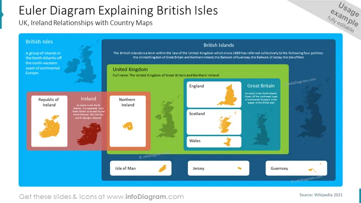
UK, Ireland Relationships with Country Maps
The slide is titled "Euler Diagram Explaining British Isles" and depicts the political and geographic relationships between the entities that make up the British Isles. The British Isles is explained as a group of islands in the North Atlantic off the north-western coast of continental Europe. The term has been used since 1889 to collectively refer to four polities: the United Kingdom of Great Britain and Northern Ireland, plus the Bailiwicks of Guernsey and Jersey, and the Isle of Man. The United Kingdom is further broken down into England, Scotland, Wales, and Northern Ireland, with Great Britain comprising England, Scotland, and Wales. Ireland is represented by two separate entities: the Republic of Ireland and Northern Ireland.
The overall look of the slide is colorful and organized, using colored rectangular areas to categorize information and map icons for visual reference. It provides a cohesive and easy-to-understand visual representation of the complex relationships between the political entities on and around the British Isles.



