Your graphics add a nice touch to my presentations and I recently used them for one of my all-hands meetings. Your toolbox adds professionalism to my slides. Instead of using standard clipart.
Claude Jones, Director of Engineer, @Walmartlabs, USA
Your graphics add a nice touch to my presentations and I recently used them for one of my all-hands meetings. Your toolbox adds professionalism to my slides. Instead of using standard clipart.
Claude Jones, Director of Engineer, @Walmartlabs, USA
I needed a fresh look at some of my slides. I've tried to find a way to create a paintbrush effect, to underline, accentuate, add some color and the handwritten markers were just the things. Very easy to use, easy to size, change the color. It was an affordable, perfect solution and I'm happy to recommend it.
Anonymous, US
The crisp, clean look of the graphics, and the fact that it allowed me to easily edit and change the colors to match the template was my main reason for purchasing them.
Brandie Jenkins, E-learning Developer, USA
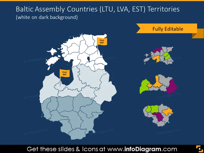
La diapositive présente un aperçu géographique des pays de l'Assemblée balte, y compris la Lituanie (LTU), la Lettonie (LVA) et l'Estonie (EST). La carte principale illustre les divisions territoriales de ces pays, mettant en évidence leurs régions individuelles. Elle est accompagnée de cartes inset plus petites, chacune mettant en avant un pays avec des régions codées par couleur pour différenciation. Des zones de texte réservées suggèrent où des informations supplémentaires peuvent être insérées, indiquant que les cartes sont personnalisables pour diverses présentations.
La diapositive présente une composition visuelle professionnelle et épurée avec une palette de couleurs contrastée qui met en avant les cartes. Les éléments sont disposés avec un bon équilibre, créant un accent sur la carte principale tout en gardant les cartes inset facilement visibles.


