

Your graphics add a nice touch to my presentations and I recently used them for one of my all-hands meetings. Your toolbox adds professionalism to my slides. Instead of using standard clipart.
Claude Jones, Director of Engineer, @Walmartlabs, USA

Your graphics add a nice touch to my presentations and I recently used them for one of my all-hands meetings. Your toolbox adds professionalism to my slides. Instead of using standard clipart.
Claude Jones, Director of Engineer, @Walmartlabs, USA
I needed a fresh look at some of my slides. I've tried to find a way to create a paintbrush effect, to underline, accentuate, add some color and the handwritten markers were just the things. Very easy to use, easy to size, change the color. It was an affordable, perfect solution and I'm happy to recommend it.
Anonymous, US
The crisp, clean look of the graphics, and the fact that it allowed me to easily edit and change the colors to match the template was my main reason for purchasing them.
Brandie Jenkins, E-learning Developer, USA
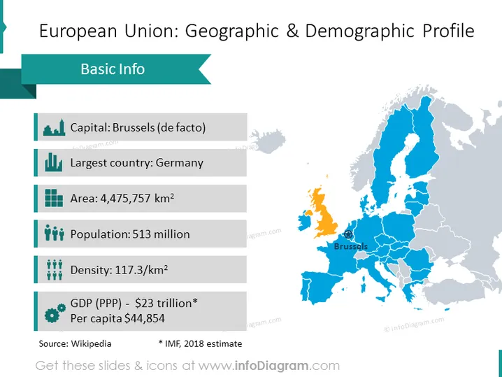
Die Folie mit dem Titel "Europäische Union: Geografisches und demografisches Profil" bietet grundlegende Informationen zur EU. Die Hauptstadt wird als Brüssel angegeben, das de facto Verwaltungszentrum. Deutschland wird als das größte Land identifiziert, was seinen bedeutenden geografischen und wirtschaftlichen Einfluss innerhalb der EU widerspiegelt. Die Fläche der EU beträgt 4.475.757 Quadratkilometer, was auf ihre umfangreiche territoriale Abdeckung hinweist. Die Bevölkerung der EU wird mit 513 Millionen angegeben, was die große Anzahl der in den Mitgliedstaaten lebenden Menschen unterstreicht. Die Bevölkerungsdichte beträgt 117,3 Personen pro Quadratkilometer, was ein Gefühl für die durchschnittliche räumliche Verteilung ihrer Einwohner vermittelt. Das Bruttoinlandsprodukt (BIP) wird in Kaufkraftparität (KKP) mit 23 Billionen Dollar angegeben, wobei der Pro-Kopf-Wert bei 44.854 Dollar liegt, was auf eine erhebliche wirtschaftliche Stärke und den Wohlstand pro Einzelperson hinweist. Die Quelle wird als Wikipedia zitiert, und es wird weiter klargestellt, dass die BIP-Zahl eine Schätzung des Internationalen Währungsfonds (IWF) für das Jahr 2018 ist.
Das Gesamtbild der Folie ist ausgewogen und professionell, mit klaren Unterscheidungen zwischen Text- und Grafikelementen. Der Einsatz von Symbolen und Farbcodierungen hilft, die Art der aufgelisteten Informationen und den geografischen Kontext schnell zu vermitteln.



